


Garmin GPSMAP 1022 Chartplotter
R41,599
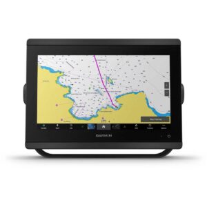
The Garmin GPSMAP 1022 Chartplotter features a vivid 10″ colour display with wide viewing angles, giving you clear visibility and detailed chart information from different positions at the helm. Designed for reliable navigation, it is compatible with Garmin’s premium maps and charts, delivering the best of Garmin’s mapping technology for both inland and coastal use.
Description
Garmin GPSMAP 1022 Chartplotter
The Garmin GPSMAP 1022 Chartplotter features a vivid 10″ colour display with wide viewing angles, giving you clear visibility and detailed chart information from different positions at the helm. Designed for reliable navigation, it is compatible with Garmin’s premium maps and charts, delivering the best of Garmin’s mapping technology for both inland and coastal use. With Garmin Marine Network support, the unit allows information sharing between multiple connected devices onboard, streamlining navigation and system management.
The built-in 10 Hz GPS and GLONASS receiver updates your position and heading ten times per second, ensuring smooth, fluid movement across the screen during navigation. Waypoints, tracks and routes can be transferred easily from other GPS devices using industry-standard GPX formatting, allowing you to bring your existing navigation data onto the new system effortlessly. While the GPSMAP 1022 model itself does not include sonar, it supports sonar technology on select compatible variants, and transducers are sold separately.
Although this specific model has no built-in sonar, the chartplotter series includes versions capable of single-channel CHIRP sonar, CHIRP ClearVü and CHIRP SideVü scanning, as well as Panoptix and LiveScope sonar support. Built-in ANT connectivity allows wireless pairing with compatible Garmin devices, including quatix marine watches, gWind Wireless 2 transducers, GNX Wind instruments and wireless remotes.
Wi-Fi connectivity enables full use of the ActiveCaptain all-in-one app, allowing access to smart notifications, chart features, software updates and the ability to manage your marine experience from a compatible smartphone. Navigation features are further enhanced with Garmin SailAssist, offering a polar table, laylines, set and drift details, and true and apparent wind data when used with the appropriate sensors.
Optional Garmin Navionics+ and Garmin Navionics Vision+ cartography provide integrated content, daily updates and Auto Guidance+ technology for more intuitive route planning. The Garmin GPSMAP 1022 Chartplotter supports Garmin Marine Network, NMEA 2000 and NMEA 0183, allowing sonar, radar, maps, user data and more to be shared across compatible devices.
Engine connectivity allows viewing of key data such as RPM, fuel flow, temperature and trim when supported by your engine system. The chartplotter also pairs with inReach satellite communicators, enabling custom message creation directly from the display. Integration with Power-Pole shallow water anchors and the CHARGE Marine Power Manager brings advanced anchoring features, battery monitoring, emergency start capabilities and power allocation control—all accessible from your chartplotter. The Garmin GPSMAP 1022 Chartplotter offers a strong, navigation-focused platform built to enhance performance and connectivity on the water.
FEATURES
- Get wider viewing angles on a vivid 10″ or 12″ colour display.
- These are compatible with our premium maps and charts for the best in Garmin navigation.
- Share information among multiple units, thanks to Garmin Marine Network support.
- See fluid position and heading changes with update rates of 10 times per second.
- Easily transfer waypoints, tracks and routes from your other GPS devices.
- See what’s around your boat with built-in sonar capabilities on select models (transducers sold separately).
SPECIFICATIONS
- Dimension: 31.8 x 18.5 x 6.9 cm
- Weight: 1.85 kg
- Water rating: IPX7
- Display Type: WSVGA display
- Display Size: 22.4 x 12.5 cm; 10.1″ (25.7 cm) diagonal
- Display Resolution: 1024 x 600 pixels
- Mounting Options: Bail or flush
- Input: Keyed
PACKAGE CONTENTS
- Garmin GPSMAP 1022 Chartplotter
- Power/data cable
- NMEA 2000 T-connector
- NMEA 2000 drop cable (2 m)
- Bail mount kit with knobs
- Flush mount kit with gasket
- Protective cover
- Trim piece snap covers
- Documentation
Only logged in customers who have purchased this product may write a review.


Reviews
There are no reviews yet.