
Garmin BlueChart G3 Vision Western Africa Coastal Charts
R6,599
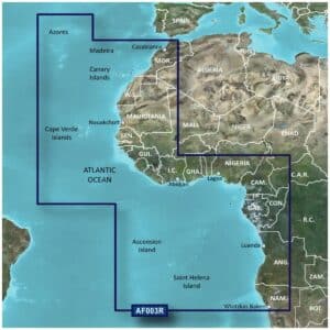
The Garmin BlueChart G3 Vision Western Africa Coastal Charts are designed for mariners seeking advanced navigation along the Western African coastline.
Description
Garmin BlueChart G3 Vision Western Africa Coastal Charts
The Garmin BlueChart G3 Vision Western Africa Coastal Charts are designed for mariners seeking advanced navigation along the Western African coastline. Delivered on a microSD/SD card, these charts provide navigational aids, spot soundings, depth contours, tidal and current information, and detailed harbor and marina layouts from both official and private sources.
BlueChart g3 Vision adds high-resolution relief shading, unique 3-D views, high-resolution satellite imagery, and aerial photos to give a realistic perspective of coastal and port areas. Depth Range Shading for up to 10 depth ranges allows quick identification of target depths, while 1-foot contours accurately depict the bottom structure, improving navigation in shallow waters, canals, and marinas. Shallow Water Shading further enhances safety by highlighting critical depth zones.
These charts are compatible with devices featuring a microSD/SD card slot and can be explored on a computer with Garmin BaseCamp™ for detailed planning. The package includes both a microSD card and SD card adapter, providing the mariner with advanced chart detail and visualization tools for confident navigation.
FEATURES
- Integrated Garmin and Navionics content
- Auto Guidance¹ technology
- Depth range shading
- Up to 1′ contours
- Shallow water shading
- Raster cartography²
- High-resolution relief shading
- Unique 3-D views
- High-resolution satellite imagery
- Aerial photos
Only logged in customers who have purchased this product may write a review.


Reviews
There are no reviews yet.