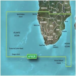
Garmin Navionics+ Vision+ NVAF002R South Africa Marine Charts
R5,499Navigate South Africa’s coastal and inland waters with precision and confidence using the Garmin Navionics+ Vision+ NVAF002R South Africa Marine Charts.
Welcome to the ultimate collection of marine electronics in South Africa. Whether you’re a professional angler or a weekend boating enthusiast, our range of advanced fish finders and GPS chartplotters is designed to give you a clear advantage on the water.
We stock the latest models from leading brands like Garmin, featuring powerful sonar technology, side-scan imaging, and crystal-clear displays. Discover everything from portable kayak fish finders to sophisticated fish finder/GPS combo units that integrate seamless navigation with detailed underwater views.
A quality chartplotter is essential for safe navigation, and our units provide detailed marine charts, waypoint marking, and route planning. Don’t just search for fish; find them with precision. Browse our selection today and equip your boat with the best marine GPS and fish-finding technology on the market.
Showing 61–85 of 85 resultsSorted by price: high to low

Navigate South Africa’s coastal and inland waters with precision and confidence using the Garmin Navionics+ Vision+ NVAF002R South Africa Marine Charts.
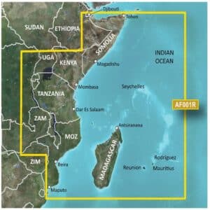
Explore East Africa’s coastal and inland waters with confidence using the Garmin Navionics+ Vision+ NVAF001R East Africa Marine Charts.
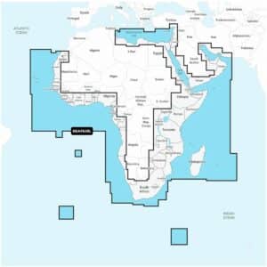
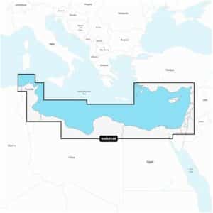
Navigate Africa and the Middle East with precision using the Garmin Navionics+ NSAF630L Africa & Middle East Marine Charts. This comprehensive mapping solution comes on a microSD™/SD™ card and includes a one-year subscription for daily chart updates and new content downloads.
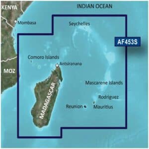
The Garmin BlueChart g3 Vision VAF453S Indian Ocean Charts provide premium navigation across the Indian Ocean, Mascarene Plateau and Madagascar. These charts combine official and private sources for accurate navigational aids, spot soundings, depth contours, tides and currents, and detailed harbors and marinas.
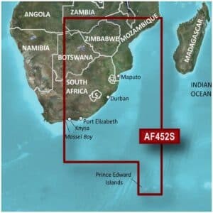
The Garmin BlueChart g3 Vision VAF452S Knysna to Beira Charts provide premium navigation along the southeastern African coast, combining official and private sources for reliable navigational aids, spot soundings, depth contours, tides and currents, and detailed harbors and marinas.
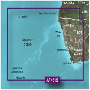
The Garmin BlueChart G3 Vision VAF451S Namibia To Knysna Charts offer premium navigation for mariners along the southern African coast.
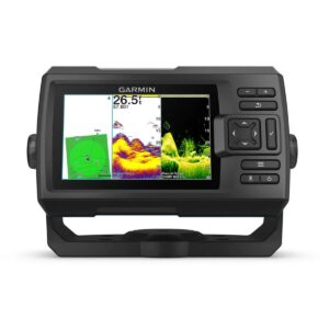

The Garmin Garmin STRIKER Vivid 5cv GPS Fishfinder is a versatile 5-inch fishfinder designed to provide anglers with clear and detailed views of fish and underwater structures. Featuring a high-sensitivity GPS, it allows you to mark waypoints, create routes, and view your boat’s speed, helping you navigate and return to productive fishing spots with ease.
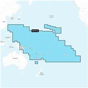
Garmin Navionics+ NAPC014L Pacific Islands Marine Charts provide a comprehensive mapping solution for a wide range of compatible chartplotters, combining reliable coastal and inland content with advanced navigation tools.
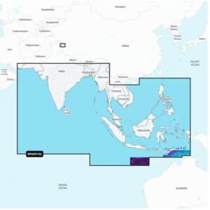
Garmin Navionics+ NAAE010L Indian Ocean & South China Sea Marine Charts deliver an all-in-one mapping solution designed for a wide range of compatible chartplotters. Covering extensive coastal and inland areas across the Indian Ocean and South China Sea, this chart package combines detailed cartography with advanced navigation features to support confident route planning for cruising, sailing and offshore fishing.
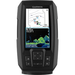
The Garmin STRIKER Vivid 4cv GPS Fishfinder is a versatile 4-inch fishfinder designed to provide anglers with clear, detailed views of fish and underwater structures. Featuring a high-sensitivity GPS, this fishfinder allows you to mark waypoints, create routes, and view your boat’s speed, ensuring you can navigate and return to productive spots with ease.
The Garmin BlueChart G3 Western Africa Coastal Charts provide advanced navigational detail for safe and confident boating along the Western African coastline.
The Garmin BlueChart G3 Southern Africa And Inland Charts provide advanced navigational detail for confident boating and fishing across Southern Africa’s coastal and inland waters.
The Garmin BlueChart G3 Eastern Africa Coastal and Inland Charts provide advanced navigational detail for confident boating and fishing along Eastern Africa’s waters.
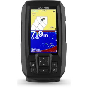

The Garmin STRIKER Plus 4 GPS Fishfinder is a compact and powerful 4.3-inch fishfinder with built-in GPS, designed to give anglers crystal-clear sonar imaging and precise navigation on the water. Featuring a dual-beam transducer with Garmin CHIRP traditional sonar, it delivers detailed images and remarkable target separation, making it easier to identify fish and underwater structures.
Garmin Navionics+ NAEU016R Mediterranean Sea, Southeast Marine Charts deliver a comprehensive, detail-rich mapping solution designed for a wide range of compatible chartplotters.
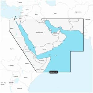
Garmin Navionics+ NAAW010R The Gulf & Red Sea Marine Charts deliver an integrated mapping solution designed for a wide range of compatible chartplotters, combining clear coastal and inland detail with advanced guidance features.
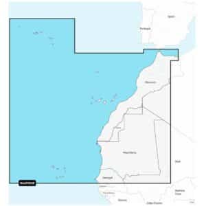
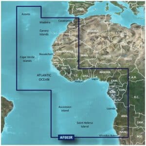
Garmin Navionics+ NAAF004R Northwest Africa Marine Charts provide an integrated mapping solution designed for a wide range of compatible chartplotters, offering clear and reliable coverage across both coastal and inland waters.

Garmin Navionics+ NAAF005R West Africa Marine Charts deliver an integrated mapping experience designed for a wide range of compatible chartplotters, providing clear and reliable coverage across both coastal and inland waters.
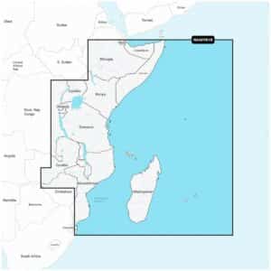
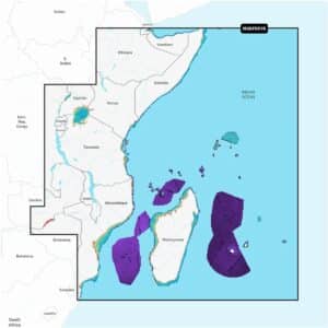
The Garmin Navionics+ NAAF001R East Africa Marine Charts provide a comprehensive, all-in-one mapping solution on microSD™/SD™, complete with a one-year subscription that covers all charts, maps and downloaded content.

The Garmin Navionics+ NAAF002R South Africa Marine Charts provide a comprehensive, all-in-one mapping solution on microSD™/SD™, complete with a one-year subscription that includes access to all downloaded charts, maps and content during that period.
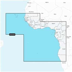
Explore West Africa’s coastal and inland waters with the Garmin Navionics+ NSAF005R West Africa Marine Charts. This all-in-one mapping solution delivers detailed coverage of coastal features, lakes, rivers, harbors, and marinas.

Navigate Northwest Africa’s coastal and inland waters with ease using the Garmin Navionics+ NSAF004R Northwest Africa Marine Charts. This all-in-one mapping solution provides comprehensive detail of coastal features, rivers, lakes, harbors, and marinas.
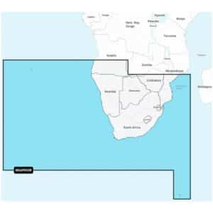
Navigate South Africa’s coastal and inland waters with confidence using the Garmin Navionics+ NSAF002R South Africa Marine Charts. This complete mapping solution combines Garmin and Navionics® content to provide detailed coverage of coastal features, rivers, lakes, harbors, and marinas.

Explore the East African coastline and inland waters with confidence using the Garmin Navionics+ NSAF001R East Africa Marine Charts. This premium mapping solution combines Garmin and Navionics® content to provide comprehensive coverage of coastal features, lakes, rivers, harbors, and marinas.
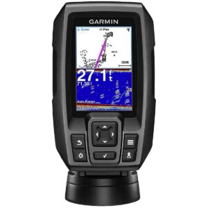
The Garmin STRIKER 4 GPS Fishfinder is a compact and easy-to-use 3.5-inch colour fishfinder designed to help anglers locate fish quickly and efficiently. Featuring a built-in high-sensitivity GPS, this fishfinder allows you to mark your favourite fishing spots, docks, and ramps and return to them with precision.